Roles of Pre-fire Vegetation, Soil, and Climate in Great Basin Ecosystem Recovery
This project was completed as part of my master's work funded through the Joint Fire Science Program's Graduate Research Innovation (GRIN) program. We used remote sensing and spatial modeling approaches to analyze plant species diversity as a covariate to post-fire vegetation recovery. The project funded supplemental field data collection and travel and publication expenses
- Project lead Eric Jensen
- Collaborators Jody Vogeler, Beth Newingham
- Website Final Report
- Tools Google Earth Engine, R, ArcGIS Pro
- Completed December 2020
ABOUT THE PROJECT
Project Summary
Great Basin shrublands in the United States are rapidly converting to annual grassdominated ecosystems, driven primarily by increased wildfire activity. Post-fire vegetation recovery trajectories vary spatially and temporally and are influenced by the effects of topography, climate, soils, and pre-fire vegetation. Our study leverages spatially continuous Landsat data alongside spatial environmental datasets to evaluate drivers of post-fire vegetation recovery. We first evaluated the spectral diversity hypothesis, which suggests that variation in remotely sensed spectral values relates to plant species diversity. In turn, plant species diversity is theorized to be an important predictor of ecological resilience to disturbance and resistance to invasive species. Weak relationships between spectral diversity measures and plant species diversity led us to explicitly model plant species richness with Landsat spectral information and environmental variables. We applied the model of plant species richness to produce annual maps of predicted species richness from 1994–2017.
We assessed post-fire recovery in terms of the impacts of frequent fire activity on postfire communities, whether post-fire seeding improves recovery outcomes, and by explicitly modeling post-fire plant communities. We found that repeated fires had a cumulative effect leading to increased annual herbaceous invasion and diminished perennial plant components. Meanwhile, on average, post-fire seeding treatments had negligible influence upon post-fire perennial plant recovery. Importantly, post-fire recovery trajectories varied significantly across the region, underscoring the importance of spatial evaluations of recovery patterns. The model of post-fire recovery produced strong validation statistics when averaged across all fires and more tempered results when applied to new fires not included in model development. Notably, plant species richness was not a strong enough predictor variable to be included in the final model.
Spatially continuous analyses are important as they can account for variability in post-fire recovery of Great Basin shrublands. While such analyses have previously been hampered by data and computing limitations, our results suggest that these approaches are increasingly tractable. Most importantly, spatially explicit approaches such as this provide valuable maps to land managers that can inform data-driven post-fire management.
Key Figures
Species richness modeling and Landsat spectral heterogeneity analysis
We initially tested relationships between 94 unique measures spectral heterogeneity of Landsat TM, ETM+ and OLI, imagery and a plant species richness (using 10,471 field plots), finding weak but highly significant relationships at the broad extent of the Great Basin.
We then modeled plant species richness directly using random forest and XGBoost algorithms with 220 spectral, soils, fire, climate, and topography variables as candidate predictors. We used variable reduction to remove multicollinear and correlated variables and to select the most predictive layers, which produced and r-squared of 0.52 when applied to our validation dataset. The ten most predictive layers closely matched those found in similar field studies.
We produced predictive maps of plant species richness for Great Basin shrublands for each year from 1994-2017, finding distinct spatial pattern at broad scales that coincide with understood patterns of plant invasion and altered fire regimes.
Post-fire vegetation recovery analysis and modeling
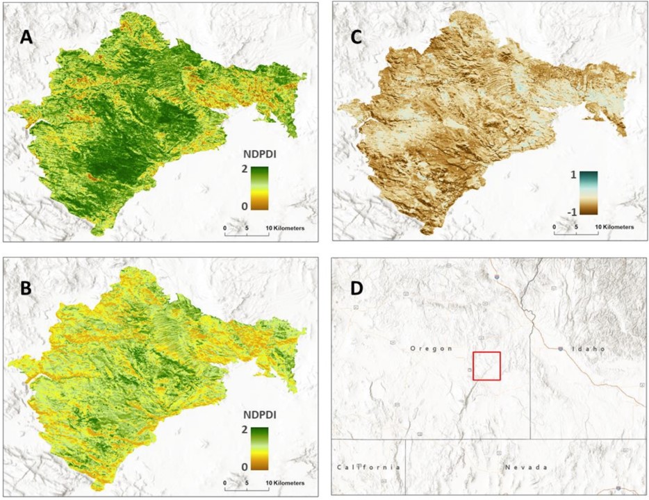
We evaluated the role of the repeated fire and post-fire management on vegetation recovery trajectories using the Normalized Differenced Perennial Dominance Index (NDPDI) as a response variable. We found that repeated fire had a cumulative affect of diminished post-fire recovery overall, but with variability across the region. In terms of seeding, no appreciable improvement in post-fire recovery was found as a result of seeding when compared to unseeded areas.
We then used vegetation,soils, fire, climate, management, and topography variables to explicitly model post-fire vegetation recovery 15-years following fire using random forest modeling, selecting 17 variable for the final model. We validated the model using conventional methods (r-squared of 0.83) and using leave-one-out validation (mean r-squared of 0.34). Overall, pre-fire vegetation, climate aridity, and southern aspects and high heat load indices played driving roles in post-fire vegetation outcomes.
The final analysis focused on predicting post-fire recovery patterns for a contemporary fire, the Saddle Draw Fire which burned 284,065 acres in southeastern Oregon in 2014. We produced a predictive map of post-fire recovery depicting NDPDI 15-years following the fire.